I did them. I was ready to discuss them in class when they were assigned. It was never clear we needed to write about them as well as read/discuss them.
As such, I don't have the time/energy to revisit them all, re-read them AND then write about them.
I spent about 60 hours on the final project. It consumed me. It consumed my brain. I gave all I had left of me to that project.
Fin.
Tuesday, May 19, 2015
Outside Event III
I went to MakerFaire 2015. Photos sum it up better than words. The Google Story is a bit more fun than a column of photos placed in this blog. Click the link above.
Wednesday, May 13, 2015
Life in the Cracks I
Life in the Cracks I is an exploration of relationships within familiar territories seeking to lay bare and make visible that which is often ignored, overlooked or marginalized.
The presence of nature is often highly curated and reconstructed to fit neatly into a rigid and structured system in an urban setting. Wild and unrelenting, nature occupies and resists. It takes hold, renegotiating ownership – taking back the forgotten cracks, crevices, fissures and fractures – of planned space.
Overlooked and dismissed, our perception is shaped by privilege. “Weeds” are a nuisance – an object to be eradicated as they do not fit our construct of aesthetically pleasing and purposeful. We have
collectively forgotten the wisdom and agency of the plant world.
Life in the Cracks I seeks to shift the narrative by creating a mechanism to negotiate and navigate
resistance in the programmed world.

Final Paper
What is a map? Asking this question will generate as many different responses as the number of people you ask. Maps hold a myriad of meanings that vary based upon the context of the question. Maps allow us to define ourselves, our allegiances, our histories and our future.
While the word map evokes ideas of travel, place, space and physicality, we also use “maps” to guide us through our daily lives – agendas, calendars, to do lists, mind maps, syllabi – these are all maps that guide us to some sort of destination.
Even looking at the definition of the word map in the dictionary creates a vague understanding of what a map is. Again, context is key in understanding the notion of a map. Is it being used as a noun or a verb? Is it being used to define territory or define our day? In this context, just looking at the definition of the word map, it seems as though the word really has no concrete meaning. This is interesting considering the general acceptance of maps to define and guide. The context of the use is largely equivalent to the meaning of the word itself.
In The New Nature of Maps, J.B. Harley asks the question “What is a map?” Again, we are faced with varying answers based upon to whom the question is posed. On one end of the spectrum we have the view that “the nature of maps is that they are a mirror, a graphic representation, of some aspect of the real world.” (Harley), but when asking a historian the same question bears the answer leans toward “a social construction of the world expressed through the medium of cartography.” (Harley)
More interestingly, Harley contends that cartography is an art of persuasion. When we look at what maps convey to the user, this is a plausible contention. Again, context is key. While we look at maps as being scientific, factual and accurate means of communicating data, ultimately we need to look at who has made the map and who has commissioned said map. Historically (and concurrently) maps have been used to exert authority, power and legitimize rule. Maps mark territory – be it literal or figurative. “Maps redescribe the world – like any other document – in terms of relations of power and cultural practices, preferences and priorities.” (Harley) In A History of the World in Twelve Maps, Jerry Brotton rightly proclaims “The world is always changing, and so are maps.” Considering the power constructs that maps often represent, this is a very accurate statement.
Keeping these ideas of authority, power and rule in mind, we must change how we perceive maps. They are not coldly scientific, unbiased factual records as we often treat them. Harley posits that maps are “images of the world, maps are never neutral or value free or ever completely scientific.” In looking at the historical context (and current context), cartographers were (and are) the means to an end for the person or entity commissioning the work. The system in which maps are made is not dissimilar from the patron/artist construct we have seen through the ages. In considering this relationship, one can make the connection between the desires of the patron and the message of the maps made.
In one context, maps tell us where to go. They guide us to our destination and orient us in unfamiliar territory. In another context, those same boundaries and borders tell us where not to venture. In the history of mapping, there has been a variety of ways to delineate boundaries and borders, the known from the unknown. We make assumptions that are influenced by our world view, but we can never be certain as to the true intention of the map as intended by its commissioner. Borders become fluid and ever changing. They are open for interpretation and disagreement. Conflict is common based upon the interpretation of borders. Simon Garfield illustrates this with the recounting of Google’s attempt to map the world. “As it becomes more powerful, Google finds that it encounters obstacles it never anticipated, often geopolitical and social ones that seldom detained mappers with empire-building intent in centuries past… When the Nicaraguans invaded Costa Rica, they blamed Google Maps for doing it because our borders weren’t right.”
Taking this information into consideration along with preconceived notions of what a map is, there are now more questions than answers shaping my view of maps. Never had I considered maps to be anything other than a factual and accurate representation of the physical world. Overall, the course of this semester helped shape how I view maps. Instead of something concrete and scientific, maps are far more fluid than I had previously thought. Additionally, maps were put into perspective as a system of classification of non-spatial data. While I still may have a bit of trouble conceptualizing mapping as art, it is now a more readily available tool for analysis. Maps are all around us and it is our responsibility to interpret them objectively and questioningly.
Works Cited
Brotton, Jerry. A History of the World in Twelve Maps. London: Allen Lane, 2012.
Garfield, Simon. On The Map. New York: Gotham Books, 2013.
Harley, J.B. The New Nature of Maps. Baltimore: Johns Hopkins University Press, 2001.
Wednesday, May 6, 2015
Project Progress
This project took a few turns along the way. I originally started with the idea of mapping my fridge - watching how it changes from day to day. But after realizing how gross my fridge really is (and the seeming inability to throw things out in my house), I questioned that idea.
Then I started a map of my block (the space between 5th Street, 6th Street, Harrison Street and Folsom Street). We all have fear lingering in the backs of our minds that our landlord will decide to take advantage of the ridiculous real estate market and sell forcing us out. I thought about mapping the property values and the single residences that have been torn down to make room for multi story buildings.
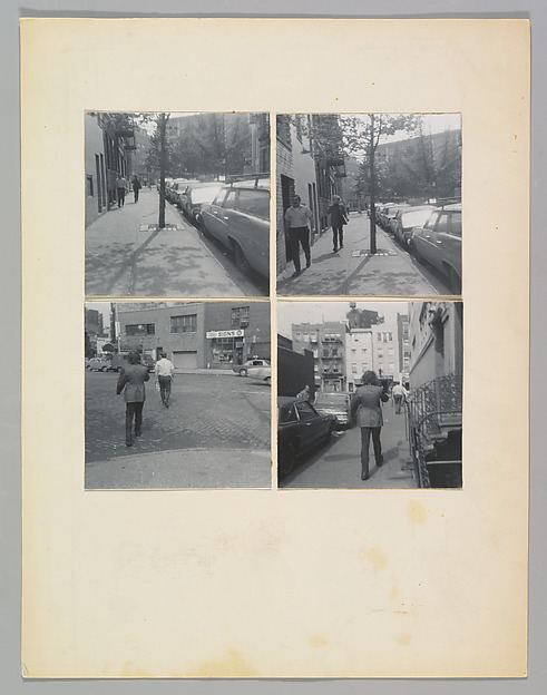
A slow walk with my dog made me realize how much life is lived in the cracks of my neighborhood.
Life abounds in even the most derelict environments. My sidewalks and all the cracks between the buildings, curbs and fences are filled with life. It is life that many people dismiss as "weeds" but almost all plants have purpose. In some ways, I have started to see the plants as metaphor for the people as well that dwell in the cracks - we all have purpose, even when it's not obvious.
I grabbed my camera and set out to take photos, but there is no good angle to photograph from. I normally don't hesitate to lay on the ground to capture a photo, but in a neighborhood coated with soot, grime, urine and feces, I wasn't quite ready to drop to the ground.
The first hurdle was how to identify the plants. There are a few plant identification apps but they involved uploading an image and waiting for someone somewhere to identify the plant and send you a message. Given the time constraints for this project, that wasn't going to work.
Next I tried using Google Image search... Yeah. That didn't work. It analyzed the whole image and found similar images but none of that helped identify the plants themselves.
Next I hit a list of "weeds" in San Francisco. Jackpot.
Cal-IPC
California Native Plants
CA Wildflowers - Wikipedia
There were a few other sites as well. I spent about 20 hours visually identifying the plants from the photos I had taken. I was able to identify 14, but there were quite a few more living in the cracks. In all likelihood, this project could be a full time job for months on end just trying to identify the numerous plants that populate a single block.
I had already created the map, but hadn't been sure how to visualize what I was recording. The photos weren't what I wanted. It felt slap dashed together and it was more of a visualization for a proposal than an actual project I was going to want to have printed and show.
Enter the paintings. I don't normally paint. But I love botanical illustrations more than anything and many of them are done in watercolor. I hate painting. I hate cleaning up. It's so messy. I often end up having a reaction to paint if it gets on my hands. It's just NOT fun for me.
But I have a Wacom Tablet. I have Corel Painter 11 (and now Corel Painter 2015) and it is the most amazing thing ever. Pressure sensitive brush control. A variety of media to choose from. I used to use it for rendering in some digital design classes and hadn't used it due to the lack of digital work done at SFSU and lack of time!

Then I started a map of my block (the space between 5th Street, 6th Street, Harrison Street and Folsom Street). We all have fear lingering in the backs of our minds that our landlord will decide to take advantage of the ridiculous real estate market and sell forcing us out. I thought about mapping the property values and the single residences that have been torn down to make room for multi story buildings.
A slow walk with my dog made me realize how much life is lived in the cracks of my neighborhood.
Life abounds in even the most derelict environments. My sidewalks and all the cracks between the buildings, curbs and fences are filled with life. It is life that many people dismiss as "weeds" but almost all plants have purpose. In some ways, I have started to see the plants as metaphor for the people as well that dwell in the cracks - we all have purpose, even when it's not obvious.
I grabbed my camera and set out to take photos, but there is no good angle to photograph from. I normally don't hesitate to lay on the ground to capture a photo, but in a neighborhood coated with soot, grime, urine and feces, I wasn't quite ready to drop to the ground.
The first hurdle was how to identify the plants. There are a few plant identification apps but they involved uploading an image and waiting for someone somewhere to identify the plant and send you a message. Given the time constraints for this project, that wasn't going to work.
Next I tried using Google Image search... Yeah. That didn't work. It analyzed the whole image and found similar images but none of that helped identify the plants themselves.
Next I hit a list of "weeds" in San Francisco. Jackpot.
Cal-IPC
California Native Plants
CA Wildflowers - Wikipedia
There were a few other sites as well. I spent about 20 hours visually identifying the plants from the photos I had taken. I was able to identify 14, but there were quite a few more living in the cracks. In all likelihood, this project could be a full time job for months on end just trying to identify the numerous plants that populate a single block.
I had already created the map, but hadn't been sure how to visualize what I was recording. The photos weren't what I wanted. It felt slap dashed together and it was more of a visualization for a proposal than an actual project I was going to want to have printed and show.
Enter the paintings. I don't normally paint. But I love botanical illustrations more than anything and many of them are done in watercolor. I hate painting. I hate cleaning up. It's so messy. I often end up having a reaction to paint if it gets on my hands. It's just NOT fun for me.
But I have a Wacom Tablet. I have Corel Painter 11 (and now Corel Painter 2015) and it is the most amazing thing ever. Pressure sensitive brush control. A variety of media to choose from. I used to use it for rendering in some digital design classes and hadn't used it due to the lack of digital work done at SFSU and lack of time!
Saturday, April 18, 2015
Final Project Ideation
Mapping intimate spaces...
First we have to ask what is "intimate"? Is it a personal space that is yours alone? Can it be a public space that you have made your own? How do we as individuals define intimacy?
Let's take a look at the meaning of the word....
Given the nature of the word, this assignment could take any direction.
My first thought was to map my fridge. It's a space in my home that no one considers other than myself (because I can never find space for food since it's often filled with beer). It's a place that people stick things in, often never to think of them again. (I end up clearing out the fridge because no one else can be bothered to throw out their leftovers.. We often have things sitting in there for months that should be long gone.)
I went home from class and started creating my strategy for this project. I spent a good hour inventorying the freezer (which is the emptiest part).... and photographing the freezer.
I was using the Out of Milk app in hopes to speed up the process, but it was still slow going. I was scanning the barcodes but not every item can be scanned.
I moved on to the fridge, but after an hour with the door alone, I started to reconsider the project. I've been taking photos of the fridge and freezer 2x a day since Wednesday, but I am not feeling a connection with the project on the whole.
I went on a walk today with my dog and she was limping along. It was the slowest walk ever, as she hobbled along and decided to lay on the ground. As I was looking at the ground trying to get her up, I started to notice the plants that take hold in the smallest nooks with the tiniest amounts of dirt possible.
I am going to create a map of my block using google earth and mark the spots where I find plants growing. I will then use Illustrator to create an illustrated map of my block's botany.
I don't try to hide the fact I don't like San Francisco. There isn't really much that makes me appreciate the city. But sometimes when I slow down and notice the little things like flowers blooming in the squalor, it makes it a bit more bearable.
First we have to ask what is "intimate"? Is it a personal space that is yours alone? Can it be a public space that you have made your own? How do we as individuals define intimacy?
Let's take a look at the meaning of the word....
2intimate
adjective in·ti·mate \ˈin-tə-mət\: having a very close relationship : very warm and friendly: very personal or private: involving sex or sexual relationsFull Definition of INTIMATE
2: marked by very close association, contact, or familiarity <intimateknowledge of the law>3a : marked by a warm friendship developing through long association<intimate friends>b : suggesting informal warmth or privacy <intimate clubs>4: of a very personal or private nature <intimate secrets>
Given the nature of the word, this assignment could take any direction.
My first thought was to map my fridge. It's a space in my home that no one considers other than myself (because I can never find space for food since it's often filled with beer). It's a place that people stick things in, often never to think of them again. (I end up clearing out the fridge because no one else can be bothered to throw out their leftovers.. We often have things sitting in there for months that should be long gone.)
I went home from class and started creating my strategy for this project. I spent a good hour inventorying the freezer (which is the emptiest part).... and photographing the freezer.
I was using the Out of Milk app in hopes to speed up the process, but it was still slow going. I was scanning the barcodes but not every item can be scanned.
I moved on to the fridge, but after an hour with the door alone, I started to reconsider the project. I've been taking photos of the fridge and freezer 2x a day since Wednesday, but I am not feeling a connection with the project on the whole.
I went on a walk today with my dog and she was limping along. It was the slowest walk ever, as she hobbled along and decided to lay on the ground. As I was looking at the ground trying to get her up, I started to notice the plants that take hold in the smallest nooks with the tiniest amounts of dirt possible.
I am going to create a map of my block using google earth and mark the spots where I find plants growing. I will then use Illustrator to create an illustrated map of my block's botany.
I don't try to hide the fact I don't like San Francisco. There isn't really much that makes me appreciate the city. But sometimes when I slow down and notice the little things like flowers blooming in the squalor, it makes it a bit more bearable.
Outside Event 2 - Picture Puzzle Pattern Door @ YBCA
Thursday was Third Thursdays at Yerba Buena, which also was ConVerge at the Gallery. An evening of free admission to the YBCA galleries and performances.

I didn't have enough notice to share to the class (sorry), but I happened upon it using Google FieldTrip - If you still haven't checked it out, do it. It helps you find stuff in your area you may not otherwise know about. :)
Shanna Moulton's Picture Puzzle Pattern Door is an interdisciplinary installation that features audio, video, collage and interactive installations.
I wasn't able to stay for the live performances, but I did make my way through the galleries.
My favorite part of the installation was MentalWave SitPlace, a round seating area that featured the ThoughtStream USB Personal Biofeedback Unit. The participant uses the biofeedback unit to relax using tones and galvanic response registered by a hand sensor. I spent a while there and sort of want to get one myself.
A lot of the other work was collage from magazine and collections of items as well as a gallery that played 4 videos simultaneously.
The videos used a lot of green screen to allow the artist to place her self in different scenes. Much of the work had New Age and self actualization undertones but also felt sort of cheesy in a 1980's low budget way.
Tuesday, April 14, 2015
Possible Paper Topics
The thought of a paper has thrown me off.

Not that I can't think of something to write, I always can.
I am troubled by the idea of trying to explore cartography in this way. I am, at times, still struggling to blaze my path into some of the more conceptual pieces we have looked at. Occasionally, this is too far out of my comfort zone. I find myself asking the question "is this REALLY art?".
But then again, I find myself asking that question on the regular. I have a friend who works exclusively in piano. I can't say I truly understand this and while it's interesting to look at, does that really make it art?
Truth be told, I don't know.
Is art the process or the product? Is it the invisible statement or the written statement that often accompanies it.
But mapping, it's a part of our life. Every day. Even when you don't think about it. Your calendar is a map to your day. Your contacts list is a map to your connections. Your grocery list is a map tied to your kitchen.
Possible topics...
Historical origins of map iconography - Maps were often beautifully illustrated with sometimes fantastical creatures. Where did those come from? When did elements of maps become "standard"?
What happens to cartography when everyone becomes a cartographer. I ask myself this question about a lot of topics with the advances of technology. Photography used to be a specialized thing, but seriously, I can snap better quality photos on my phone than the camera I bought even 5 years ago AND edit the photos on my phone. What effect, if any, does this phenomena have on mapping?
Wednesday, April 1, 2015
Doug McCune Show
Unfortunately it's not in SF :(
Type A Machines had shared a link about the opening for this show and since they are a local company, I clicked on it thinking "Sweet, I'll totally go to this tomorrow"
Yeah, not so much.
Here's a link to the info.
Super sad it's in OR and not in SF.
Type A Machines had shared a link about the opening for this show and since they are a local company, I clicked on it thinking "Sweet, I'll totally go to this tomorrow"
Yeah, not so much.
Here's a link to the info.
Super sad it's in OR and not in SF.
Sunday, March 29, 2015
Outside Event 1 - Hydrarchy and Globalization panel discussion
I hadn't really seen the exhibit prior to attending the panel discussion so I think I went into it having an entirely different impression of what it was going to be about.
Based upon the description of the panel (and my understanding of the exhibit), I thought there would be more discussion of the dynamic of the ocean and globalization.
Ultimately I felt as though much of the discussion was based upon imposed and man made geopolitical dynamics.
Truth be told, I did arrive late due to MUNI and a standing appointment with another professor that had been moved 4 times so I missed some of the presenters but was present for
- Weston Teruya
- Victor De La Rosa
- Paula Levine
I was familiar with the work of Paula Levine and Victor De La Rosa, having taken classes with them a number of times.
It was interesting to hear Weston Teruya discuss his work.
Do Your Feet Hurt? Part II
After a bit of tweaking, I think I got 1000 miles down to my liking. I used a total of 24 images created by walking through diatomaceous earth across black paper that were then scanned into digital copies.
I originally just worked with the copies as is and created a video that features 1000 images played at a steady pace, but it didn't feel right.
I originally just worked with the copies as is and created a video that features 1000 images played at a steady pace, but it didn't feel right.
I watched it and it made me feel as though it was a tightrope walk, so I decided to do some additional work on the piece.
I decided to take the images into Photoshop and widen the images (area to the left for a right foot, area to the right for left foot). This allowed a feeling of steps being properly aligned instead of walking the tightrope.
For the revised version I also played with timing. I varied the playback speed randomly throughout to mimic the varied patterns of gait when we walk. Our walk speed depends on so many things: energy level, terrain, shoe, weather, etc. Our walks change constantly - from minute to minute even.
I considered doing a bit of data bending to add some audio to the video but didn't find that the sound output enhanced the video in anyway.
As I watched through it several times, it made me feels as though it was a silent meditation on the journeys we take every day. Remember, this distance was not as though I set out to reach it. In fact, the times I was out doing things that would have boosted my mileage the most, I was not wearing my tracker at all.
These miles are the accumulation of the mundane. Going to the grocery store. Going to school. Even going to the bathroom.
We don't often observe the small details of our lives. In some ways, personal trackers allow us to observe the small details after the fact. Personally, I think the tracker has made me more mindful of what I do.
APPs that MAP: Field Trip
I stumbled upon a mention of an app that vibrates when you approach locations where women made history but then couldn't remember where I saw it.
I spent the last week racking my brain trying to figure out where I saw it finally found it.
Apparently it is part of the effort of the SPARK Movement and Google Field Trips (neither of which I was familiar with before reading about the addition of notable women to Field Trip).
A bit on Field Trips:

Here's a screenshot from me sitting in my office. Much of the historical stuff is about a mile east of me in downtown San Leandro, but the Weekend Sherpa article about Oyster Bay Regional park features a mention of Drake's Barrel House, which is below my office.
It seems like a cool app in theory, but I don't know if I like the idea of it running in the background and collecting my location information at all times.
I'll play with it and see how I feel after a few days.
I spent the last week racking my brain trying to figure out where I saw it finally found it.
Apparently it is part of the effort of the SPARK Movement and Google Field Trips (neither of which I was familiar with before reading about the addition of notable women to Field Trip).
A bit on Field Trips:
"Field Trip is your guide to the cool, hidden, and unique things in the world around you. Field Trip runs in the background on your phone. When you get close to something interesting, it pops up a card with details about the location. No click is required. If you have a headset or bluetooth connected, it can even read the info to you."Since we have talked a bit about AR and some of the applications of AR, this seems like an interesting application. The app uses your geographic location to populate information (both historical and current) about your location.
Here's a screenshot from me sitting in my office. Much of the historical stuff is about a mile east of me in downtown San Leandro, but the Weekend Sherpa article about Oyster Bay Regional park features a mention of Drake's Barrel House, which is below my office.
It seems like a cool app in theory, but I don't know if I like the idea of it running in the background and collecting my location information at all times.
I'll play with it and see how I feel after a few days.
Monday, March 23, 2015
Do your feet hurt? Part 1
I wasn't really sure where to go with the revision of my first project. I considered doing at "virtual tour" based on my weekend trip... Which then morphed into looking at my Fitbit data.
In a one year period, I walked about 1000 miles. I get a lot of whoas and wows over that, but really, it could have been higher. Considering dead batteries, forgetting to put it back on after charging and thinking it was dead a couple of times (it died just after the one year mark in February - I just got a new one today), 1000 miles was a conservative mileage.
I had an idea to photograph the soles of my shoes and make some sort of image out of that using the number of steps I had taken (3mil plus), but that was going to be super time consuming.
Working with the idea of my shoes, I considered making imprints of my soles using some sort of white powder on black paper (going back to my desire to map my yoga mat at the beginning of the semester).
I came home one night and used diatomaceous earth to create impressions of my feet on black art paper. I was a bit saddened and felt like I was wasting perfectly good paper that I had purchased for another project, but it was the only paper I had that would allow me to do this. (I did find out later that with a chamois, I can actually remove most if not all traces of the DE from the paper).
I then hung the imprints at various intervals around my room and allowed them to "record" my day to day life. A brush here and there disturbed the dust and left traces of our lives on each imprint.
I scanned them and am currently assembling them into an animation.
Monday, March 16, 2015
Walking Games...... (Jurassic Journey)
Okay, this ended up being a bit more complicated (yet easier) than I thought and it could have gone on forever.
We had hoped to use AR to create this event, but we were unable to find an AR engine that was easily accessible and free.
That sent us back to the drawing board. We wanted to try to send people to new locations they may not have been aware of based on a series of choices. We checked out a few different chose your own adventure generators (cyocyoa, inkle, quest, Google Docs) and ultimately decided on Twine.
Using a program called Twine, we created an interactive text based game. Depending on your level of coding knowledge, this platform can get very involved. There are additional ways to code video and sound into the story, but I have really basic coding skills at this point and need to work on that.

Candace and I decided to make an interactive game that can be found here.
Or here:

We also prepared a physical map that accompanied the tour.

While I think we had envisioned using more technology involved in the project, I ultimately enjoyed the outcome. I could have continued on and on with choices and locations.
And now I may be addicted to creating choose your own adventure stories.
We hope you enjoy it.
We had hoped to use AR to create this event, but we were unable to find an AR engine that was easily accessible and free.
That sent us back to the drawing board. We wanted to try to send people to new locations they may not have been aware of based on a series of choices. We checked out a few different chose your own adventure generators (cyocyoa, inkle, quest, Google Docs) and ultimately decided on Twine.
Using a program called Twine, we created an interactive text based game. Depending on your level of coding knowledge, this platform can get very involved. There are additional ways to code video and sound into the story, but I have really basic coding skills at this point and need to work on that.
Candace and I decided to make an interactive game that can be found here.
Or here:
We also prepared a physical map that accompanied the tour.
While I think we had envisioned using more technology involved in the project, I ultimately enjoyed the outcome. I could have continued on and on with choices and locations.
And now I may be addicted to creating choose your own adventure stories.
We hope you enjoy it.
Thursday, March 5, 2015
AR Generation
I'm still in the really early stages of AR research but have found a few things to check out.
I haven't actually checked any of these out yet, but they are on my to do list.
https://zapcode.it/
http://www.augmentedplanet.com/2012/06/layar-creator-code-free-augmented-reality/
http://www.junaio.com/get-started/
http://www.instructables.com/id/Creating-your-Augmented-RealityAR/
http://www.metaio.com/creator/
http://www.mobilefish.com/services/pattern_marker_generator/pattern_marker_generator.php
http://www.freetech4teachers.com/2011/02/daqri-build-your-own-augmented-reality.html#.VPi0L3zF_To
www.daqri.com
Threes
I am a walker by nature.... It's where I do most of my thinking... but I still have trouble thinking of it walking as art. I'm trying to be open to it... and hope that looking at the work of others will expand my thinking.
Walking is contemplative...Walking can be solitude. You can use it to walk away from your problems. You can use it to walk toward resolution.
I had an interesting conversation about walking with the Chaplain of the hospice program my brother was in and it lead me to realize that I often use walking as a means to escape my problems... She had mentioned that she spent an entire summer walking in her youth (it was some tremendous distance that I can no longer recall) but after a while, she realized that she was trying to distance her self from a problem in her life.
At that time, I was probably walking 2-3 hours a day.... If I wasn't at my brother's home, the yoga studio or making food to take to my family at my brother's, I was walking in the woods. It gave me something other than my thoughts to focus on.
As I look back, the other time in my life that I spent that much time walking was when I was about 16. My parents were getting a divorce (we didn't even know they were having problems) and I walked.... and walked and walked. And ever really thought about why I was walking (I did lose a bunch of weight so that made me super happy).
Walking is a meditation for me. And I am having trouble trying to translate that into an experience for others.
A few of the artists I have found that use walking are:
Vito Acconci

walkyourcity
While not necessarily and artist or collective, I came across walkyourcity.org and though it was interesting that people are getting involved in publicly placing signs to guide others. Users basically plan a walk and submit it to walkyourcity and they print and send you signs to put up in your area. Users are then able to scan qr codes and get directions to follow the signs.
Walking is contemplative...Walking can be solitude. You can use it to walk away from your problems. You can use it to walk toward resolution.
I had an interesting conversation about walking with the Chaplain of the hospice program my brother was in and it lead me to realize that I often use walking as a means to escape my problems... She had mentioned that she spent an entire summer walking in her youth (it was some tremendous distance that I can no longer recall) but after a while, she realized that she was trying to distance her self from a problem in her life.
At that time, I was probably walking 2-3 hours a day.... If I wasn't at my brother's home, the yoga studio or making food to take to my family at my brother's, I was walking in the woods. It gave me something other than my thoughts to focus on.
As I look back, the other time in my life that I spent that much time walking was when I was about 16. My parents were getting a divorce (we didn't even know they were having problems) and I walked.... and walked and walked. And ever really thought about why I was walking (I did lose a bunch of weight so that made me super happy).
Walking is a meditation for me. And I am having trouble trying to translate that into an experience for others.
A few of the artists I have found that use walking are:
Vito Acconci
Vito Acconci created the Following Piece in 1969 by following a random stranger through NYC until they entered a private space of some sort.He did this every day for one month and created a photo series that reflected his action.
A little creepy in my mind. I would be a little weirded out by some guy following me until I went into a private space. If you think about all of the space we cover in a day that is "public", a person could be followed for quite some time. This totally just feeds in to my paranoia about being followed.
A little creepy in my mind. I would be a little weirded out by some guy following me until I went into a private space. If you think about all of the space we cover in a day that is "public", a person could be followed for quite some time. This totally just feeds in to my paranoia about being followed.
Todd Shalom and company create curated walks that are "non-recorded journeys" and that patrons should "live as they happen."
"Elastic City artists work in a variety of disciplines, including poetry, urban design, dance, painting, architecture, photography, filmmaking, screen printing, sound art, theater and psychotherapy.Each artist forms their walk/way in their own terms. Some map it out beforehand and then make changes. Others set out walking and then take notes. Most are adapting their talents to the walk format for the first time. For those offering "ways," they are pushing their craft through an experiential workshop whose limits are still undefined.All of the artists are provocative in their questioning and rigorous in their design. Please click on their names for more info."
walkyourcity
While not necessarily and artist or collective, I came across walkyourcity.org and though it was interesting that people are getting involved in publicly placing signs to guide others. Users basically plan a walk and submit it to walkyourcity and they print and send you signs to put up in your area. Users are then able to scan qr codes and get directions to follow the signs.
Thursday, February 26, 2015
Do Your Feet Hurt????
Over the last 54 weeks, I have walked more than 3 million steps.....
This made me start thinking about my shoes. Personally, I don't care for shoes. They feel unnatural to me. I feel like my feet are entombed and doomed to an eternity of solitary confinement when I wear them.
I love to feel the connection I have to the world around me through my feet. I can't explain it, but if I'm having a bad day, a few minutes of foot to earth contact makes it better (well, that and red lipstick - red lipstick makes any day a better day).
It turns out I have been into earthing since childhood. I grew up in a rural area where going outside barefoot was no big deal. My mom hated shoes as well, when I was growing up (and then she asks where I got my hippie ways from), so it wasn't forced upon us. If you wanted to go outside without your shoes on, hey no big deal. God made dirt, and dirt don't hurt... was a mantra with me and my brothers (this applied to getting dirty, covered in mud, eating food that dropped on the ground, etc. - we likely had insanely great digestive biomes).
I wanted to make something more personal than a map for my personal geography. I started thinking about the shoes I have and the wear and tear they endure day in and day out. How our shoes wear tell a lot about us.
Even though I don't like wearing shoes, I have connections to those shoes. I remember the shoes I was wearing when certain events happened (the orange ballet flats that became the "lucky" shoes during the 2010 World Series), my husband's graduation party/our engagement party that was the last time I wore my black patent pumps, the hiking boots I carried through Yosemite when I had such a reaction to bug bites I couldn't keep my shoes on...
The point being, our shoes are an extension of us in some ways. As much as I love being barefoot, I no longer live a life that allows that (living in SF is a dangerous place to barefoot).
I took photos of the soles of all of my shoes, mocs and slippers and am going to create an image using the soles.
My goal is to create an image that contains 3.3 million shoe soles (this probably will not happen before this is due, but I can try to get a move on it.
I will create brushes out of each sole so I can paint with the images. Eventually I want to print it at 4'x6' (there's a printing company in my building that may be able to make it a canvas for me).
Here is a random sampling from my shoes...
Monday, February 23, 2015
Personal Geographies.... Revisited.
Ugh.
I am completely drawing a blank on how I want to revise my personal geography (superimposing my weekend driving to go to Fort Bragg over Ireland).
I could do the whole virtual tour thing and make a video in Google Earth, but I don't feel that is what I should do.
I looked at my stats on my fitbit the other day and in the last year and 20 days, I have walked approximately 965 miles (I say approximately because there are a lot of times I forget to put it back on after charging and there was a 2 week period where it appeared to have died but then was fine). In all likelihood, I'm well over 1000 miles at this point.

That's a lot of walking.... and a lot of wear and tear on shoes (when I choose to wear shoes).
I'd be barefoot all the time if I had my choice, but living in San Francisco does not allow me that luxury. I'm barely comfortable wearing flip flops for fear of being contaminated. I also prefer minimalist footwear, so I have an insane fear of stepping on needles as they would pop right through a 2 mil footbed.
Being self-employed and a student, I don't have a lot of money and I can't remember when I last bought a new pair of shoes..... I have a surprising number of shoes for a person who can't stand them, but I haven't picked up a new pair since before I started tracking my walking.
This got me thinking about a physical piece I could make instead of a virtual tour... While I am very comfortable working with technology, it doesn't feel like a "personal geography" with the direction I was headed.
I think I am going to make a piece that uses the worn treads of my shoes to create an image or texture. I think I will use black paper and white powder (likely diotomaceous earth or corn starch since I have both of those on hand already) to make the marks.
I briefly considered paint, but then got to thinking about my soft soled mocs and that would totally ruin them (the other shoes could handle rinsing washable paint from them).
I haven't quite figured out the layout I will use, but I will try to capture the wear and tear of my feet and my shoes. Perhaps this will become and ongoing thing where I capture the wear and tear from new to the point of discard for shoes going forward.
I am completely drawing a blank on how I want to revise my personal geography (superimposing my weekend driving to go to Fort Bragg over Ireland).
I could do the whole virtual tour thing and make a video in Google Earth, but I don't feel that is what I should do.
I looked at my stats on my fitbit the other day and in the last year and 20 days, I have walked approximately 965 miles (I say approximately because there are a lot of times I forget to put it back on after charging and there was a 2 week period where it appeared to have died but then was fine). In all likelihood, I'm well over 1000 miles at this point.
That's a lot of walking.... and a lot of wear and tear on shoes (when I choose to wear shoes).
I'd be barefoot all the time if I had my choice, but living in San Francisco does not allow me that luxury. I'm barely comfortable wearing flip flops for fear of being contaminated. I also prefer minimalist footwear, so I have an insane fear of stepping on needles as they would pop right through a 2 mil footbed.
Being self-employed and a student, I don't have a lot of money and I can't remember when I last bought a new pair of shoes..... I have a surprising number of shoes for a person who can't stand them, but I haven't picked up a new pair since before I started tracking my walking.
This got me thinking about a physical piece I could make instead of a virtual tour... While I am very comfortable working with technology, it doesn't feel like a "personal geography" with the direction I was headed.
I think I am going to make a piece that uses the worn treads of my shoes to create an image or texture. I think I will use black paper and white powder (likely diotomaceous earth or corn starch since I have both of those on hand already) to make the marks.
I briefly considered paint, but then got to thinking about my soft soled mocs and that would totally ruin them (the other shoes could handle rinsing washable paint from them).
I haven't quite figured out the layout I will use, but I will try to capture the wear and tear of my feet and my shoes. Perhaps this will become and ongoing thing where I capture the wear and tear from new to the point of discard for shoes going forward.
Wednesday, February 18, 2015
Personal Geographies
Okay, I remember why I hate google earth SO much.
It never seems to work the "right" way even when you follow tutorials.
I had originally planned to use my yoga mat as my personal geography but struggled with how I was going to execute the idea.
I happened to go to Mendocino over the weekend and did yoga outside on the deck, which left dirt impressions on the underside of the mat. They were very faint, so I nixed that idea.
I did leave the GPS running as much as possible over the weekend. (my car broke down and I left it in the car overnight when it was at the garage) We went through a lot of places where signals were weak and we went through a lot of batteries, but here is an image of "most" of our driving between Thursday night and Monday night.
 It was a lot of driving. This didn't capture the drive too my mom's house in Pollock Pines or parts of the drive throughout. This is the satellite capture...
I was curious as to the actual mileage and routing and put it into google maps as a multi leg trip....
About 950 all told.... Including the back and forth when my car broke down and going back and forth for that.. In fact, there were so many stops on this tour, Google Maps wouldn't let me add any more destinations.

I ended up exporting the tracks as svg files using gpsvisualizer and decided to see where that trip would have taken me elsewhere in the world.....
I decided on Ireland since both my husband and I are of Irish descent.
I used the svg to create a transparent PNG to place into Google Earth and as I was looking at it, I decided to see what I would actually see if I were there. That is the only cool thing about Google Earth. I basically got to take a tour of Ireland through the eyes of others.
I started thinking about what I would like to see and found a map of the Celtic High Crosses so I decided to see if any of it matched up. A few way points did.

I added points at places where the crosses come close to the traveled path and had inserted images in to the points. I can NEVER get the tour to pause and show an image. It just stops at the spot and moves on.
In fact, I hated this so much last time I used GE for a project, that I ended up using google maps and screencast o matic to make my video (which was great because I could do the voice over work later).
COnsidering the amount of time the GE takes to get a handle on, I am not certain as to "what" I am going to make as an art piece.
It never seems to work the "right" way even when you follow tutorials.
I had originally planned to use my yoga mat as my personal geography but struggled with how I was going to execute the idea.
I happened to go to Mendocino over the weekend and did yoga outside on the deck, which left dirt impressions on the underside of the mat. They were very faint, so I nixed that idea.
I did leave the GPS running as much as possible over the weekend. (my car broke down and I left it in the car overnight when it was at the garage) We went through a lot of places where signals were weak and we went through a lot of batteries, but here is an image of "most" of our driving between Thursday night and Monday night.
I was curious as to the actual mileage and routing and put it into google maps as a multi leg trip....
About 950 all told.... Including the back and forth when my car broke down and going back and forth for that.. In fact, there were so many stops on this tour, Google Maps wouldn't let me add any more destinations.
I ended up exporting the tracks as svg files using gpsvisualizer and decided to see where that trip would have taken me elsewhere in the world.....
I decided on Ireland since both my husband and I are of Irish descent.
I used the svg to create a transparent PNG to place into Google Earth and as I was looking at it, I decided to see what I would actually see if I were there. That is the only cool thing about Google Earth. I basically got to take a tour of Ireland through the eyes of others.
I started thinking about what I would like to see and found a map of the Celtic High Crosses so I decided to see if any of it matched up. A few way points did.
I added points at places where the crosses come close to the traveled path and had inserted images in to the points. I can NEVER get the tour to pause and show an image. It just stops at the spot and moves on.
In fact, I hated this so much last time I used GE for a project, that I ended up using google maps and screencast o matic to make my video (which was great because I could do the voice over work later).
COnsidering the amount of time the GE takes to get a handle on, I am not certain as to "what" I am going to make as an art piece.
Thursday, February 12, 2015
So it's called...... data bending....
I'm still playing with placing data into Audacity to create sounds.... And it's a thing. A thing called "data bending".
I'm still working out a standard setting to use, but have been getting interesting results when running filters...
Today I isolated the image (graph image of speed from my GPS ViewRanger experimentation) and created a transparent .gif in photoshop so I only had the line (no white background).
video of image imported as mono sound at 8000Hz, 32 bit float.
I'll be honest with you, I have no background in sound/audio so much of this is jibberish to me, but I'm going to continue playing with this to see what happens.
I'm still working out a standard setting to use, but have been getting interesting results when running filters...
Today I isolated the image (graph image of speed from my GPS ViewRanger experimentation) and created a transparent .gif in photoshop so I only had the line (no white background).
 |
| Original Data Image |
 |
| .gif transparent image |
video of image imported as mono sound at 8000Hz, 32 bit float.
I'll be honest with you, I have no background in sound/audio so much of this is jibberish to me, but I'm going to continue playing with this to see what happens.
Tuesday, February 10, 2015
ViewRanger App - Another look
I signed in to viewranger in order to have off phone access to my mapping.
What I learned is that viewranger does not immediately make your tracks available on the web, you have to "share" the tracks in order to view them. This involved going to view your tracks on the app, using the menu on the right and selecting "share".
This will ultimately upload your tracks to the web version.
When viewing your tracks, it not only shows you where you have been, but the altitude of that trip, speed and distance in a separate graph.
 This was my trip to campus last week. I took a slight detour and got off at stonestown to get some iced tea and walked the rest of the way.
I never really thought about the fact that this is a shorter trip distance wise than driving but it can take like 3x longer than driving (depending on how you hit traffic on the highway).
The only disadvantage to using apps like this is that I forget to turn my gps on..... and it kills your phone's battery.
I've been playing with the standalone gps unit Paula loaned out and found that it's hard to get a good read in SOMA. When we used them over at SFSU, I don't think I lost satellite contact, but couldn't keep a read here. My neighborhood's buildings aren't even that tall.
What I learned is that viewranger does not immediately make your tracks available on the web, you have to "share" the tracks in order to view them. This involved going to view your tracks on the app, using the menu on the right and selecting "share".
This will ultimately upload your tracks to the web version.
When viewing your tracks, it not only shows you where you have been, but the altitude of that trip, speed and distance in a separate graph.
I never really thought about the fact that this is a shorter trip distance wise than driving but it can take like 3x longer than driving (depending on how you hit traffic on the highway).
The only disadvantage to using apps like this is that I forget to turn my gps on..... and it kills your phone's battery.
I've been playing with the standalone gps unit Paula loaned out and found that it's hard to get a good read in SOMA. When we used them over at SFSU, I don't think I lost satellite contact, but couldn't keep a read here. My neighborhood's buildings aren't even that tall.
Tuesday, February 3, 2015
Apps that Map(p)
I have to say this was a bit harder than I thought....
There are a ton of apps that do basically the same thing and I don't have a ton of storage space on my phone (the existing apps are my work apps).
The fitbit app (you need a fitbit to work with it) is sort of a mapping tool, as it maps your activity (see my exercise one post to see an example) in a graph to visualize how active you are. Unfortunately, I have a fitbit, but my phone is not compatible with the app (my previous phone was), so I rely upon using the fitbit desktop to sync my data.
 |
| January 26, 2015 Daily Activity Graph - Fitbit |
Unfortunately a lot of mapping apps require you to sign up for an account. I get tired of being forced to sign up (and provide my data), so that eliminated a lot of the apps I looked at (like map my walk, map my ride, map my run, etc.). I used to use a lot of these apps years ago when they didn't require any form of sign up. They basically use your phone's gps data to keep maps of where you've been and the duration of your "trip".
I no longer keep my gps enabled at all times (or really even remember to turn it on unless I'm using navigation, which is rare), so not a lot of use to me there.
The 3rd I tried was Viewranger. When I opened it up, it did give me the option to check it out without signing up.... That was a plus. ... The initial location was really accurate. When I turned my GPS on, it then placed me in the last place I used GPS (about an hour away in Brentwood). After a few minutes, it found me back in SF and was only one house off from my actual location.
I set it to record my track on the way to school so we will see what happens.
Exercise 1 - A Year in Steps (audio file)
I've been wearing my fitbit tracker for almost a year (there have been some times where I go to charge it and forget to put it back on and there was a week or two it seemed to stop working) and was looking at the data from it.
I decided to take a screen clipping of the last year and see if I could map that data into an audio file... Guess what, I did it.

I started by reviewing my data in the fitbit dashboard and took a screen clipping using Microsoft oneNote (if you aren't using this you should be).
I took the image into Illustrator and used stars to map the points of each week.

I did a couple of tests to see what would work better for the audio translation and the star points worked better than the graph itself.
Thursday, January 29, 2015
The Map, The Art
I've come across the work of Shane Hope before and I was drawn back to it for several reasons. 1. His work feels almost as though you are looking at a map and 2. It's 3d printing related. With the rising popularity of 3D printing, it's hard to keep up with everyone who is developing ideas, but his work has popped on my radar from time to time.
His work often looks like chaotic maps, but in actuality they are very small 3d printed algorithms and molecular studies that are layered together to create collages (While I do enjoy looking at his work, I really feel like he elevates his artist-speak to supreme dbag levels - this may or may not have something to do with trying to get the art community to take 3d printing seriously, but that's another post.).


 |
| Nano-Nonobjective No. 81 2014 3D-printed PLA on panel 6″x6″ |
I just happened to stumble upon this and found it interesting as it is somewhat related to a project my husband has been kicking around for a few years using brainwaves to create art. Ion Popion and Thomas Martinez have collaborated to translate brain activity into 3d printed art pieces.
The last example I found was an illustration by D.W. Kellogg circa 1830's-1840's.
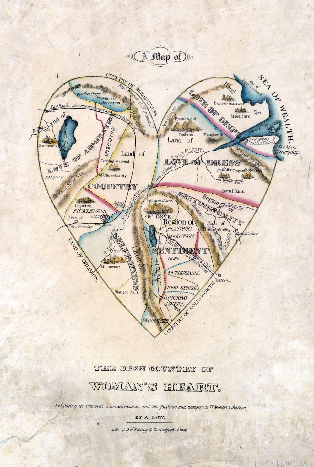
I found it interesting because it was a lovely illustration but considering that it is illustrating what womanhood was supposed to be based on popular culture, it's illustrating an idealized woman. I think a lot about how women are constantly bombarded by outside influences on who they are and how they should behave, but never really gave thought to it being an ongoing cultural influence of popular culture. What made me slightly sad though, it that it seems that women have really grown into and accepted the tenets outlined here. Perhaps it's just the place I've been but it really seems as though "Woman as a sentimental, selfish, and superficial being driven by vanity, it places Love at the center of her heart, with Good Sense, Patience, and Prudence at its tip — or bottom, depending on the interpretation" is now the norm.
Subscribe to:
Comments (Atom)